|
|||||||||||||||
|
|||||||||||||||
|
|
The Lightning Imaging Sensor (LIS), is a space based instrument used to detect the distribution and variability of total lightning (cloud-to-cloud, intracloud, and cloud-to-ground lightning) that occurs in the tropical regions of the globe. The LIS is a science instrument aboard the TRMM Observatory, which was launched on 28 November 1997 from the Tanegashima Space Center in Japan. This calibrated lightning sensor uses a wide field-of-view expanded optics lens with a narrow-band filter in conjunction with a high speed charge-coupled device detection array. A Real Time Event Processor (RTEP), inside the electronics unit, is used to determine when a lightning flash occurs, even in the presence of bright sunlit clouds.
Data from the Lightning Imaging Sensor is being used to study mesoscale phenomena such as storm convection, dynamics, and microphysics. These will be related to global rates and amounts and distribution of convective precipitation, as well as to the release and transport of latent heat, which are all influenced by global scale processes.
The LIS instrument is part of the Tropical Rainfall Measuring Mission (TRMM). TRMM is a joint mission between NASA and the National Space Development Agency (NASDA) of Japan designed to monitor and study tropical rainfall and the associated release of energy that helps to power the global atmospheric circulation shaping both weather and climate around the globe.
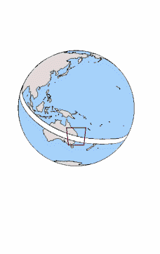
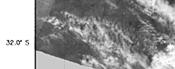
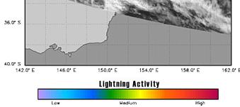
Example Lightning ObservationsThe image below depicts some lightning activity that was observed by the Lightning Imaging Sensor (LIS) on its first day of operation (November 30,1997). The thunderstorms that produced this lightning activity were located near the eastern coast of Australia. An examination of this example image demonstrates that not all clouds produce lightning. Due to the relationship between lightning and updraft velocity, lightning activity can be used to identify locations of strong upward convection.
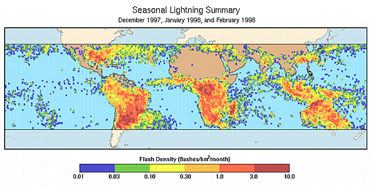
Three months of LIS data were combined to form a "lightning climatology map", shown below. This period corresponds with the summer season in the Southern Hemisphere and the winter season in the Northern Hemisphere. The orbit of the TRMM Observatory has an inclination of 35 degrees. As a result, the LIS instrument, which is part of the TRMM Observatory, can observe lightning activity where it occurs the most: between 35 degrees South latitude and 35 degrees North latitude.
|
||||||||||||||||||||||
|
|
|
| Home
| Primer | Dataset Info | Research
& Observations | Validation | Bookshelf
| Government Compliance Privacy, Security, Notices |
|
|
|
|
| NASA Contact:
Steve Goodman, Ph.D. Site Curator: Danny Hardin |
 |
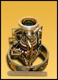 This
lightning sensor consists of a staring imager which is optimized to locate
and detect lightning with storm-scale resolution (4 to 7 km) over a large
region (600 x 600 km) of the Earth's surface. The TRMM Satellite travels
a distance of 7 kilometers every second (nearly 16,000 miles per hour) as
it orbits the Earth, thus allowing the LIS to observe a point on the Earth
or a cloud for almost 90 seconds as it passes overhead. Despite the brief
duration of an observation, it is long enough to estimate the flashing rate
of most storms. The instrument records the time of occurrence, measures
the radiant energy, and determines the location of lightning events within
its field-of-view.
This
lightning sensor consists of a staring imager which is optimized to locate
and detect lightning with storm-scale resolution (4 to 7 km) over a large
region (600 x 600 km) of the Earth's surface. The TRMM Satellite travels
a distance of 7 kilometers every second (nearly 16,000 miles per hour) as
it orbits the Earth, thus allowing the LIS to observe a point on the Earth
or a cloud for almost 90 seconds as it passes overhead. Despite the brief
duration of an observation, it is long enough to estimate the flashing rate
of most storms. The instrument records the time of occurrence, measures
the radiant energy, and determines the location of lightning events within
its field-of-view.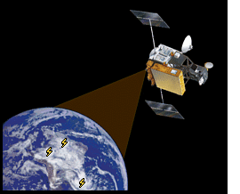 Weak lightning signals that occur during the day are hard to detect
because of background illumination. The RTEP will remove the background
signal, thus enabling the system to detect weak lightning and achieve a
90% detection efficiency.
Weak lightning signals that occur during the day are hard to detect
because of background illumination. The RTEP will remove the background
signal, thus enabling the system to detect weak lightning and achieve a
90% detection efficiency. The LIS instrument was designed by the GHCC Lightning Team and
was manufactured at the Marshall Space Flight Center in Huntsville, Alabama.
LIS will contribute significantly to several TRMM mission objectives by
providing a global lightning and thunderstorm climatology from which changes
(even subtle temperature variations) might be easily detected.
The LIS instrument was designed by the GHCC Lightning Team and
was manufactured at the Marshall Space Flight Center in Huntsville, Alabama.
LIS will contribute significantly to several TRMM mission objectives by
providing a global lightning and thunderstorm climatology from which changes
(even subtle temperature variations) might be easily detected.