|
|||||||||||||||
|
|||||||||||||||
|
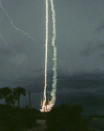
For many investigations, lightning must be observed from as close a vantage point as possible. One technique is to probe inside hostile thunderstorms in order to study how thunderclouds electrify, but this does not ensure close-up encounters with lightning. Close-up measurements are difficult to obtain because of the unpredictability of where and when lightning will strike. Hence, methods have been developed to create lightning discharges under somewhat controlled conditions. Rocket-triggered
lightning research has been an important tool With this technique, small sounding rockets connected to long copper wires have replaced Franklin's kite. These rockets are launched into thunderstorms with electronic sensors located near the bottom end of the wire instead of a key. When the rocket is struck by lightning, the wire is vaporized. Data collected before and during the occurrence of lightning provide detailed information of the discharge's characteristics. Sounding rockets can also provide in-cloud measurements of thunderstorms in a challenging environment. While extensive ground based optical and electrical measurements of lightning have been made, the emphasis has been on cloud-to-ground discharges with little study of intra-cloud lightning being undertaken. This is partly due to the fact that optical measurements of in-cloud lightning are severely affected by light scattering from water droplets within the cloud. For this reason, ground-based measurements alone have not been considered an appropriate means for determining the optical characteristics of lightning as viewed from above. Much has been learned from these aircraft observations. For example, they have confirmed C. T. R. Wilson's theory that strong electric fields over the tops of thunderstorms cause conduction currents to flow to the tops of clouds. The penetrative convective cells which rise above the anvil are the most active electric regions in the storm and cause the most intense electrical stresses, as seen from high altitude aircraft.
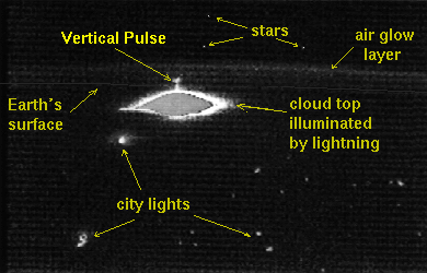
The ER-2 has a larger payload capability than its predecessor the U-2. Both have provided direct observations of severe thunderstorms and other clouds using multi-sensor payloads including lasers, infrared, visible and microwave scanners, spectrometers, and electric field antennas. To complement the optical measurements from aircraft, video lightning images have been taken during a number of space shuttle flights while conducting the Mesoscale Lightning Observation Experiment (MLE). These observations have revealed many interesting lightning events. For example, on April 28, 1990, a video image from space showed a single stratospheric luminous discharge appearing to move upward into clear night air. This was recorded on the space shuttle STS-32 mission using the payload bay TV camera. The
direction of this event has not been firmly established, however,
the stratospheric discharge is of interest because it may provide
evidence for a theory postulated by C. T. R. Wilson Stratospheric lightning could potentially deposit significant energy into the stratosphere, causing important chemical perturbations. In addition, these lightning events may generate strong electric fields and electromagnetic pulses which might interact with the Earth's ionosphere and magnetosphere. Finally, strong fields at high altitudes may generate runaway electrons which could then produce high energy x-rays and even gamma rays. Thus, it is possible that lightning may generate electromagnetic radiation, ranging from extremely low frequency to gamma radiation. Researchers from the Geophysical Institute at the University of Alaska have confirmed shuttle observations by capturing images on videotape of what appear to be brief flashes of light emanating from thunderstorms into the stratosphere. These "stratospheric optical flashes", also known as "red sprites", were photographed from NASA's DC-8 Airborne Laboratory while flying at an altitude of about l2 km during a night-time mission to videotape lightning over Iowa and Kansas during June and July of 1993. Stratospheric flashes are brief, persisting for less than about a tenth of a second. They appear to be associated with intense thunderstorm activity, but are both rare and fainter than typical cloud-to-ground or intra-cloud lightning. Unlike familiar ground level lightning events that are electrical discharges confined to narrow channels, the flashes appear to cover a relatively broad horizontal extent of several miles, and to extend to altitudes of perhaps as much as 95 km, or about 60 miles.
National and regional lightning networks which use magnetic direction finders, time of arrival techniques, or VHF interferometry, provide important lightning and storm information. For a number of years, the Federal Government assisted in the financing of a national lightning data service combining independently operated systems into one network. Used primarily for operational evaluation by NOAA, it evolved into a product with substantial value for both private industry and by other Federal agencies. By 1991, recognition of the importance of lightning detection had become apparent with economically viable commercially-sponsored systems coming into existence. The Atmospheric Research Systems, Inc. (ARSI) time-of-arrival (TOA) system provides 11 Lightning Position And Tracking Systems (LPATS) which cover the U.S. and extend hundreds of miles into both oceans and beyond the borders of Canada and Mexico. ARSI ground strokes lightning data includes information on latitude and longitude, date and time, polarity, and amplitude. Recently, GDS purchased the ARSI system, and is in the process of combining the direction finding and time of arrival techniques into a single comprehensive network. Internationally, two very different types of lightning detection and location networks have been developed. The SAFIR two-dimensional VHF interferometer system developed by the French aerospace research organization ONERA and commercialized by Dimensions of France, is used to provide detailed information on all types of lightning activity within a relatively small area. The VLF Arrival-Time Difference (ATD) system designed and operated by the United Kingdom Meteorological Office, detects and locates lightning at very long range, but with less detection efficiency. In addition, other networks cover portions of Europe, Asia, Australia, China, and Canada.
While the database continues to be enlarged, the available data are spotty, making a comprehensive history of global lightning behavior impossible to produce. However, direct digital OLS data are becoming available now which will greatly improve and expand the global lightning database which is an important reference dataset. Lightning annual, interannual , and seasonal variations could then be compared with other global datasets (e.g. precipitation; global and regional synoptic patterns) both to improve understanding of the role of lightning on a global basis and to use lightning as an indicator of global change.
Present measurements indicate that an average of almost 1 ampere of current flows into the stratosphere during the active phase of a typical thunderstorm. Therefore, to maintain the fair weather global electric current flowing to the surface, one to two thousand thunderstorms must be active at any given time. While present theory suggests that thunderstorms are responsible for the ionospheric potential and atmospheric current for fair weather, the details are not fully understood.
Ground-based radio frequency measurements of global rates have significant uncertainties and limitations. A high resolution space based sensor is necessary in order to help eliminate some of the present uncertainties associated with measuring global lightning activity.
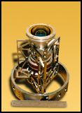
The OTD is a highly compact combination of optical and electronic elements. It was developed as an in-house project at NASA's Marshall Space Flight Center in Huntsville, Alabama. The name, Optical Transient Detector, refers to its capability to detect the momentary changes in an optical scene which indicates the occurrence of lightning. The OTD instrument is a major advance over previous technology in that it can gather lightning data under daytime conditions as well as at night. In addition, it provides much higher detection efficiency and spatial resolution than has been attained by earlier lightning sensors. At the heart of the system is a solid-state optical sensor similar in some ways to a TV camera. However, in overall design and many specific features, OTD had to be uniquely designed for the job of observing and measuring lightning from space. Like a TV camera, the OTD has a lens system, a detector array (serving a function somewhat analogous to the retina in the human eye), and circuitry to convert the electronic output of the system's detector array into useful data.
Rainfall is at the heart of Earth's unique ability to sustain life as we know it. Vegetable, animal, and human life is controlled to a large degree by the availability of moisture. On the global scale, heat released by the condensation of water vapor is a principal cause of motion in the atmosphere. Tropical rainfall, due to its abundance, plays a significant role in this process. The measurement of rainfall is a difficult challenge due to its high spatial and temporal variability. Tropical rainfall is especially difficult as it is relatively inaccessible to in situ measurements. Launched in November, 1997, TRMM is a space based system for measuring tropical rainfall and its variations. Its orbit is circular, at an inclination of 35 degrees to the equator, and at an altitude of 350 km. The low altitude of TRMM provides high resolution images, thus, more accurate rainfall measurements are obtained over very small areas of the globe. TRMM is an international collaboration with Japan, providing the first Precipitation Radar (PR) in space. The PR instrument provides information on 3-D rainfall distributions over both land and ocean. A multichannel microwave radiometer, referred to as the TRMM Microwave Imager (TMI), provides information on precipitation content, and the real distribution and intensity of rainfall. The Visible InfraRed Scanner (VIRS) provides high resolution information on cloud coverage and type, and cloud top temperatures. The Clouds and the Earth's Radiant Energy System (CERES) is a visible and infrared sensor designed especially to measure emitted and reflected radiative energy from the Earth, and from the atmosphere and its constituents. The Lightning Imaging Sensor (LIS) is investigating the global incidence of lightning and the relationship of lightning to precipitation and other geophysical parameters.
This instrument, flying on the TRMM Observatory, was designed to study the distribution and variability of total lightning on a global basis. It consists of a staring imager which is optimized to locate and detect lightning with storm-scale resolution of 5-10 km over a large region (600 x 600 km) of the Earth's surface. The field of view (FOV) is sufficient to observe a point on the Earth or a cloud for 80 seconds, adequate to estimate the flashing rate of many storms. The instrument records the time of occurrence of a lightning event, measures the radiant energy, and estimates the location. This calibrated lightning sensor uses a wide FOV expanded optics lens with a narrow-band filter in conjunction with a high speed charge-coupled device detection array. A Real-Time Event Processor (RTEP) is used to determine when a lightning flash occurs, even in the presence of bright sunlit clouds. Weak lightning signals that occur during the day are hard to detect because of background illumination. The RTEP will remove the background signal, thus enabling the system to detect weak lightning and achieve a 90% detection efficiency. TRMM will study mesoscale phenomena such as storm convection, dynamics, and microphysics. These will be related to global rates and amounts and distribution of convective precipitation, as well as to the release and transport of latent heat, which are all influenced by global scale processes. LIS contributes significantly to several TRMM mission objectives by providing a global lightning and thunderstorm climatology from which changes (even subtle temperature variations) might be easily detected.
|
|||||||||||||||||||
| Page 1 | 2 | 3 | 4 |
|
|
|
| Home
| Primer | Dataset Info | Research
& Observations | Validation | Bookshelf
| Government Compliance Privacy, Security, Notices |
|
|
|
|
| NASA Contact:
Steve Goodman, Ph.D. Site Curator: Danny Hardin |
 |
 for close-up investigation.
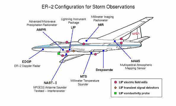
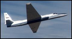 In order to determine the requirements for making
optical measurements from space, U-2 and ER-2 high altitude airplanes
have been used to study the electrical and optical characteristics
of lightning activity in thunderstorms. Flying at an altitude of 20
km and at speeds of 200 meters per second, they are capable of flying
over very large thunderstorms.
In order to determine the requirements for making
optical measurements from space, U-2 and ER-2 high altitude airplanes
have been used to study the electrical and optical characteristics
of lightning activity in thunderstorms. Flying at an altitude of 20
km and at speeds of 200 meters per second, they are capable of flying
over very large thunderstorms.
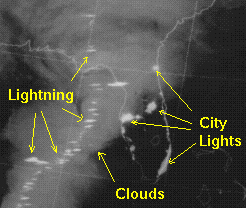
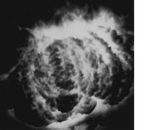 In addition, photography
of lightning from above clouds has been accomplished using an open
shutter technique. In this method, the camera is pointed toward the
thundercloud with the shutter open. In the dark nocturnal sky, no
light falls onto the film until lightning strikes. An example of an
open shutter photograph from the U-2 is shown on the left. The illuminated
storm cell depicts a convective cloud turret approximately 11 km in
height and 12 km in diameter.
In addition, photography
of lightning from above clouds has been accomplished using an open
shutter technique. In this method, the camera is pointed toward the
thundercloud with the shutter open. In the dark nocturnal sky, no
light falls onto the film until lightning strikes. An example of an
open shutter photograph from the U-2 is shown on the left. The illuminated
storm cell depicts a convective cloud turret approximately 11 km in
height and 12 km in diameter.
 in 1925. This theory predicted that electric fields can cause ionization
at great heights and could therefore give rise to discharges between
clouds and the upper atmosphere.
in 1925. This theory predicted that electric fields can cause ionization
at great heights and could therefore give rise to discharges between
clouds and the upper atmosphere.
 The National Lightning Detection Network (NLDN)
which is operated by Global Atmospherics, Inc. (GAI) in Tucson, Arizona,
is a network of at least 130 magnetic direction finders which covers
the entire United States. Each direction finder determines a direction
toward a detected electromagnetic lightning discharge. The location
of the lightning discharge is determined by triangulation. Each of
these sensors is capable of detecting cloud-to-ground lightning flashes
at a distance of 400 km away and greater. Processed information is
transmitted to the Network Control Center (NCC) in the form of a grid
map showing lightning across the U.S.
The National Lightning Detection Network (NLDN)
which is operated by Global Atmospherics, Inc. (GAI) in Tucson, Arizona,
is a network of at least 130 magnetic direction finders which covers
the entire United States. Each direction finder determines a direction
toward a detected electromagnetic lightning discharge. The location
of the lightning discharge is determined by triangulation. Each of
these sensors is capable of detecting cloud-to-ground lightning flashes
at a distance of 400 km away and greater. Processed information is
transmitted to the Network Control Center (NCC) in the form of a grid
map showing lightning across the U.S.
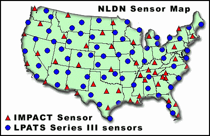 The TOA system operates by digitizing the waveform
of a received lightning signal at each sensor and accurately timing
the peak with a resolution of up to 100 nanoseconds. The difference
of arrival time at four or more receivers is then used to calculate
the location. The geographical positions of the various sensors making
up the network are shown in the U.S. map.
The TOA system operates by digitizing the waveform
of a received lightning signal at each sensor and accurately timing
the peak with a resolution of up to 100 nanoseconds. The difference
of arrival time at four or more receivers is then used to calculate
the location. The geographical positions of the various sensors making
up the network are shown in the U.S. map.
 Global lightning signatures from the Defense
Meteorological Satellite Program (DMSP) Operational Linescan System
(OLS) have been analyzed from the filmstrip imagery which is archived
at the National Snow and Ice Data Center in Boulder, Colorado. These
signatures show up as horizontal streaks on the film images. The location
of each of these streaks has been digitized in order to develop a
preliminary database of global lightning activity.
Global lightning signatures from the Defense
Meteorological Satellite Program (DMSP) Operational Linescan System
(OLS) have been analyzed from the filmstrip imagery which is archived
at the National Snow and Ice Data Center in Boulder, Colorado. These
signatures show up as horizontal streaks on the film images. The location
of each of these streaks has been digitized in order to develop a
preliminary database of global lightning activity.
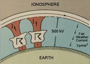 During fair weather, a potential difference of
200,000 to 500,000 Volts exists between the Earth's surface and the
ionosphere, with a fair weather current of about 2x10-12
amperes/meter2. It is widely believed that this potential
difference is due to the world-wide distribution of thunderstorms.
During fair weather, a potential difference of
200,000 to 500,000 Volts exists between the Earth's surface and the
ionosphere, with a fair weather current of about 2x10-12
amperes/meter2. It is widely believed that this potential
difference is due to the world-wide distribution of thunderstorms.