|
Section 6.17
World Lightning Map
Average U.S. Thunderstorm Days/Year
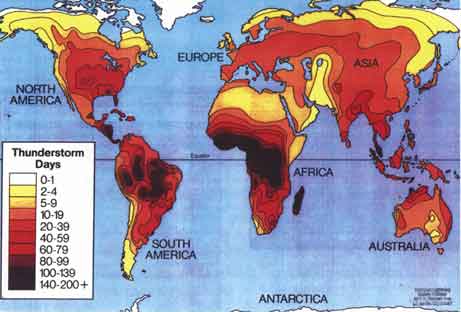
Lightning Frequency Maps are unreliable because lightning varies considerably
from year to year. However, these maps provide a general indication of
lightning activity. The following lightning maps are displayed in two
different references ~ Thunderstorm Days per Year (TD/YR) and Flash Density
per Square Kilometer (FD/KM). TD/YR are based upon human observation of
"how many days was thunder heard?" FD/KM is based upon a networked ground-based
sensor system, as provided by Global Atmospherics lnc. (see more at www.glatmos.com).
|